|
Three-bayed Watamu
Reefs of coral form much of the coast of Kenya — we don't mean the sparkling
live coral under the water some distance out, habitat of colorful
creatures, but the coral that has died and become part of the land
as gray rock. It's hard, so it erodes slowly, forming a prickly
surface; as the sea undercuts it at tide level, it takes a long
time to break and fall, so it sticks out in overhangs.
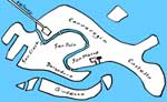
About fifty miles northeast of Mombasa
and twenty miles southwest of Malindi, a high reef makes an outwork
in front of the land, broken through by the sea to form three bays:
from southwest to northeast, Turtle Bay, Blue Lagoon, and Watamu
Bay.
Turtle Bay has a long beach which
stretches away to become a sandy strip in front of a large lagoon
or wetland. (On this strip is the brave Turtle Watch, which deserves
every bit of help in its work to protect shore life, www.watamuturtles.com.)
Watamu Bay is also without definite end, and has bits of the reef
surviving in front of it as rocky islands with their own pockets
of beach.
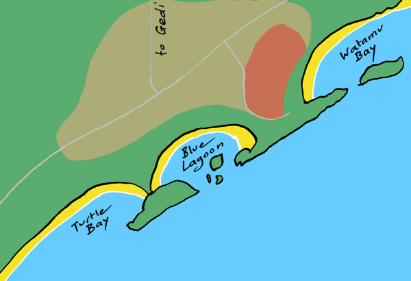
The most defined bay is the middle
one, Blue Lagoon, bounded on each side by peninsulas, pieces of
the reef shaped like hammerheads. The bay's beach is a stretched
semicircle. It has been formed rather like Lulworth Cove in England:
where the sea has broken through a wall of hard rock into a softer
area, waves spread out in curved fronts. However, the stretched
semicircle of Blue Lagoon is less definite than the remarkably almost-complete
circle of Lulworth; the entrance is much wider, and islands are
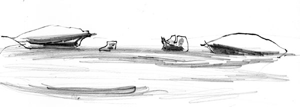
scattered in it. The bay is not deep; as the tide goes down it exposes
large almost flat areas of mingled sand and seaweed and some bits
or rock, so that you can walk out to the islands, which, with their
overhangs, look like flying saucers.
Thus you can paddle and bathe at most tide states (unlike parts
of the east coast of Zanzibar where the tide recedes over flat miles
of more or less unwalkable seaweed and waterlogged sand and you
can bathe only at high tide). The bay's schmaltzy name does not
seem apt; shallow water over sand is not blue but shades of turquoise
and cream. The drier sand has the property that if you kick your
heel into it, it squeaks. The inwashing of the waves creates one
strong symmetry: seaweed, which collects in rows along the tideline,
piles up much more deeply at the two corners of the bay, where the
beach turns sharply against the vertical rock of the headlands.
(But according to a friend who spent
much longer in this region, the appearance of the lagoons is affected
by the two monsoon seasons of the western Indian Ocean. The south-blowing
monsoon shifts the seaweed toward Turtle Bay, leaving Blue Lagoon
really blue, “or it did, sixty years ago”; the other monsoon
drives the seaweed back into the Blue Lagoon as we saw it. On a
much larger scale, it was these monsoon winds that shaped the cultural
history of East Africa, enabling the trading ships from Arabia to
reach as far south as Zanzibar at one season and to return at the
other.)
The southwest headland has a very
narrow neck, a sandy ridge with a small village of huts on it. In
other words, there will be no long time before Blue Lagoon merges
with Turtle Bay. The other headland has a broad neck; there is quite
a long walk to Watamu Bay.
The village of Watamu lies inland
from Watamu Bay and, partly, Blue Lagoon. Its Swahili name means
“sweet people”: wa-, “people“, is one
of the characteristic prefixes that abound in Bantu languages. (The
ba- in Bantu is another.) The story is that Arab slave
traders, back in the centuries when the Sultan of Oman commanded
all these coasts, found that the simple villagers could be lured
by gifts of sweets.
The local people speak not only Swahili
but their own Kigiriama language. The Giriama are one of the Mijikenda
or Nine Tribes, closely related, of the Kenya coast. Swahili, the
lingua franca of East Africa, grew on a basis of such Bantu languages
with copious borrowing of Arabic, Persian, Portuguese, German, French
and English words.
Watamu was a fishing village. It was
too snall to be marked in my 1967 edition of the great British Times
Atlas, but is marked in the updated (but otherwise inferior)
1999 edition. The beauty of its bays has caused it to grow on tourism.
People still fish, or they have jobs
related to the offshore Marine National Park, or jobs in the hotels
— during the tourist season — or they introduce themselves
to you in the street or on the beach as Captain Ali or Captain Abdillahi
and persuade you that they have boats in which to take you out snorkeling
or vans in which to take you on safari into the Tsavo game parks.
They may confide to you: “The Italians have taken all the business.”
And that a loaf of bread last year cost 80 Kenya shillings; this
year (2012), 400. Kenya is one of the worst hit by the global rise
in food prices.
An Italian resort-hotel, with pool, vast spaces under palm-thatch canopies,
a long driveway to the guarded steel gate, occupies the best part
of the Blue Lagoon frontage. Local people are kept off the beach in front of it. It is frequented mostly by Italians, and is said to be where Mafiosi hang out when Italy becomes to hot for them. The zone of palm forest between the
town and the beaches is occupied by hotels and rich houses. A German
hotel on the edge of the town caught fire, nearby houses were destroyed
and have not been rebuilt because there was no compensation. The
idyllic peninsula between Blue Lagoon and Turtle Bay, which must
once have been a heaven for Watamu children, is the private property
of a Swiss; across the peninsula's narrow neck is a steel gate and
locals can tread that soil no more.
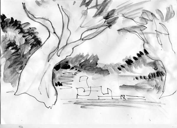
There was once a town a short way inland from Watamu: a town more important — perhaps Watamu was its footstool — yet it disappeared, and no one even knows whether its name, Gedi, is the name it had when inhabited. It disappeared into the forest, and even when existing it had a strange invisibility, as if the forest already surrounded and hid it. These are ingredients for superstitious terror, and the ruins are said to be haunted by ghosts and a huge melancholy Shadow. Gedi was a thriving Muslim Swahili city from the thirteenth century till the early sixteenth, trading widely: archaeologists have found scissors made in Spain, beads from Venice, an iron lamp from India, a Ming vase from China, and pottery from all parts of the world. Yet it was located for no known reason in a flat plain away from the Mida River and away from the sea (farther a few centuries ago, since the sea is eating into the coast). The major mystery is that there is no written record of it. Malindi, the port only fifteen miles away, was well known to the Portuguese after Vasco da Gama reached it in 1498 and used it as his base for the crossing to India, there were Portuguese traders there for a century, but apparently they never heard of Malindi's flourishing neighbor Gedi. It was abandoned for about fifty years, then was occupied for a time around 1600 by an invading band of the fierce Oromo people (formerly known as Galla) from southern Ethiopia, who terrorized the district and added to Gedi's sinister reputation.
I wanted to ride to Gedi, and bicycles are supposedly easy to hire in Watamu. The only ones we found were in the back room of a woman's little shop; I would have liked to help her, but they were a tangled pile of rust with flat tires. It was ascertained that the only hotel providing bicycles was out along the road to the south past the Turtle Watch. A gentleman named Usein took me there in his car; the place was another huge exclusive resort, and would allow its bicycles only to its guests. On the way back, Usein slowed his car beside one of the many bicycle-riders and opened a Swahili conversation: “Brother, peace be upon you . . . ” The rider cheerfully agreed to get off his bike and rent it to me, though as it wasn't actually his he had first to call its owner on his mobile phone. It had good tires and, at first, two working brakes. It was, like every bike, far too small for me, but (to generalize) African children are politer than Indian children and don't laugh at the sight of a cycling “daddy long-legs.” But riding with legs folded up made the distance along the straight and sometimes rough road seem more like eight miles than four. Just before this northward road reached the main Mombasa-Malindi highway there came a scatter of buildings, the modern village, in which there were signs such as Gede Disco and Gede Healing, and a long red-earth trackway led off eastward into forest. A square mile or so of the forest that once closed in on Gedi and hid it has been allowed to stand, amid the wider farmed landscape, and as it tries to close in again on Gedi it is thick enough to be called jungle. At the entrance to the glade which is kept open around the central group of ruins — low walls, arches, pillars, wells, sunken courtyards, mosque, palace — two gigantic baobab trees look like a gateway, but they look even more like hands, rising from the earth and leaning inward to grip.
|